
The Continental Divide
in
Oak Park
Revised January 2007
 |
|
|
|
|
|
|
|
 |
A Story of the divide in Oak Park, Illinois, with the History of the Chicago Portage and the Waterways
When we usually think of the continental divide, we think of the mountain-top spine which runs the length of the Rocky Mountains. Every point of crossing is marked with a sign announcing the divide, as if from here, all rivers flow either west to the Pacific Ocean or east to the Atlantic Ocean.
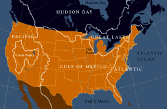 |
| Drainage Basins of the United States |
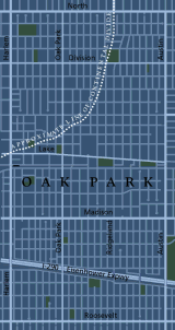 |
| Village of Oak Park showing continental divide |
The lines separating each of these great basins is a continental divide and one of these continental divides runs right through the middle of Oak Park. On the west side of our divide, waters flow to the Des Plaines River in River Forest, down to meet the Illinois River near Joliet, to the Mississippi, and finally on to the Gulf of Mexico. On the east, before the reversal of the Chicago River , the water would flow to the Chicago River, into Lake Michigan and through the Great Lakes -- Huron, Erie, over Niagara Falls into Lake Ontario, and finally to the St Lawrence in Canada and into the north Atlantic.